A Trail of Two Cities
Trans Pennine Trail from Liverpool to Manchester
Distance: approx 40 miles
Duration: 3-4 hours
Bike: Hybrid, Tourer or MTB recommended
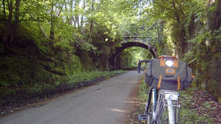
Above: Railway cutting becomes a verdant wildlife haven here on the trail in Liverpool
The Trans Pennine Trail spans the breadth of England between Southport, near Liverpool in the west, and Hornsea, near Hull in the East. At 215 miles long (350 including spurs to Leeds, Chesterfield and York) and traversing the backbone of England, the TPT is one of the country's premier long distance trails. Stringing together converted railway lines, canal towpaths, riverbanks, bridleways and minor roads, the trail is as much thoroughfare and wildlife corridor as geography and history lesson. The route began development in the 1980s as a pioneering partnership between 26 local authorities and now forms a major part of the National Cycle Network.
Whilst the most scenic stretches of the trail are undoubtedly on its higher reaches, crossing the Pennines between Manchester and the Yorkshire conurbations, the stretch between Liverpool and Manchester offers a challenging day ride through a fascinating patchwork of rural and urban landscapes, with great train links at either end.
Obviously, you can ride the route either way, but you're more likely to enjoy a tailwind if you ride the route from west to east. The Liverpool end of the trail is dominated by the Liverpool Loopline, a former railway path, which scribes an arc around the city. You can join this at many points and there are well signed on road routes leading from the city centre out to the Loopline.
The line itself is flat and completely traffic free. Passing through the suburbs of Childwall, Gateacre and terminating at Halewood, the loopline gives way to paths and minor roads, passing through Speke and the idyllic thatched-roof cottages of Hale. If you've worked up a thirst at this point, you can stop in at the Childe of Hale pub for refreshments.
From Hale the route follows the road out of the village towards Ditton and Widnes, but pretty soon you're turning right off the country road and heading towards the first scenic highlight of the ride, Pickering's Pasture, an estuarine nature reserve of international repute, with stunning views across the Mersey estuary towards the sandstone outcrops of Mersey View and Helsby Hill. It's a view where industry and nature collide with pleasing results. As you cycle along the riverside trail, the spectacular sight of Runcorn bridge awaits you, while looking back downriver, you'll see the whitewashed lighthouse at Hale Point in the distance.
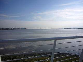
Above: Looking down the estuary towards Hale Point on the right and the Wirral peninsula on the left
At the end of the reserve you'll cross a modern steel bridge and then climb a steep switchback wooden bridge. At the top, once you've caught your breath, the trail continues along the edge of estuary on a narrow path with the industrial estate on your left. Pretty soon the trail opens out and you pass under the dramatic arches of the Runcorn road and rail bridges. The former a huge Meccano set rendered in pale green, the latter a solid sandstone arched bridge.
Once beneath the bridges you'll continue to follow the shoreline heading for the boatyard at the confluence of the Mersey Estuary and the St Helens Canal. Here you'll pass both rivergoing boats and narrowboats moored by the boating club. There's another pub here for more refreshment opportunities if you're so inclined.
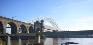
Above: The rail and road bridges across the Mersey provide a dramatic sight as you pass through Runcorn
With marshland between the canal and the River Mersey on our right, it's a birdwatchers paradise, with hides along the route catering for impromptu twitching opportunities. It's a strangely eerie place, the canal more of less returned to nature with huge reed beds lining the towpath, geese, herons and seabirds everywhere and the looming towers of Fiddler's Ferry power station on your left as you head towards Warrington.
You pass through the southern fringes of Warrington without really knowing too much about it before joining the road for a short section, crossing the River Mersey and joining the Manchester Ship Canal past the huge and impressive Latchford Locks near Thelwall.
Here you'll turn right off the road and follow signs on a great section of trail that crosses follows a former railway line, taking you through farmland towards the pretty town of Lymm. The trail here is shared with horses and has a sandy surface, braided in parts, making things interesting under-wheel. In Lymm itself there are numerous pubs and eateries just off the trail if you're feeling peckish, plus a great bike shop right on the trail for rolling repairs.
After Lymm, the trail continues on the ruler-straight former railway through Heatley and towards Altrincham. A short quiet road section then takes you north towards more gentle traffic free trails skirting the western edge of Sale and Ashton Upon Mersey. Here, the trail once again follows the River Mersey through Sale and Chorlton Water Parks. You're now on the southern skirts of Manchester, and the best option for a traffic free ride into the city centre is to cut north through Chorlton and join the Fallowfield loop (AKA the Manchester Cycleway), which circles the south of the city.
Near Gorton Reservoirs, branch left onto another traffic free path which heads north and links with the Ashton Canal, which takes you right into the city centre past the Velodrome and Sport City complex and to within a stone's throw of Manchester Piccadilly, where you'll find regular trains back to Liverpool.
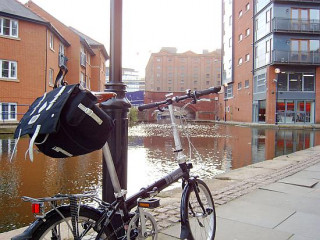
Above: The end is nigh - central Manchester and the very end of a ride dominated by fascinating waterscapes and industrial heritage.
At well over 40 miles on mixed surfaces, this is a challenging ride, despite being flat. However, the sheer variety of landscapes, paths and surfaces make the ride fly by, with each section of the ride having a distinct flavour.
The best way to navigate is to buy a detailed paper map of the route, available at http://www.transpenninetrail.org.uk/. Here you'll also find an online map which allows you to overview the route. The route is generally well signed, but there are a few points where a little intuition is required.
For more information on the Transpennine Trail, go to http://www.transpenninetrail.org.uk/