Surrey Route Guide
Road Loop: Surrey Hills
It's early on a midweek afternoon when I meet my good friend Matt outside a pub in a small Surrey village. For the first time today the sun is just starting to break through, promising warm autumnal light and long shadows. We can't help but acknowledge that winter is fast approaching.
For Matt, a teacher by profession, it is half term. He's also just a few weeks shy of becoming a father. With his agenda soon to by bombarded by sleepless nights and nappy changing duties, there seems no better time to get out on our bikes for a circuit around the lanes.
The route we take comprises some of Matt's favourite stretches of road. From the village of Capel, we pedal through Newdigate, Leigh and Betchworth, taking advantage of the flat, bucolic lanes to catch up on one another's news. When the landscape opens up with gaps in the hedgerow, we grab glances of the forested hilltops we're heading towards.


The Surrey Hills may be a designated Area of Outstanding Natural Beauty, but whichever way you look at it, the climb up through Pebble Coombe is still a bit of a pig. The gradient is 16% and the road's not particularly pleasant. The reason we come this way, though, is to reach Box Hill. The viewpoint is a bit of a Mecca for local cyclists, offering a grand panorama, a cafe and, best of all, a switchback descent back down to the valley.
At the bottom, Matt is glowing. That freefall feeling and those three sweet 180s that punctuate the drop have got the adrenaline pumping. He does have one complaint, however: "Only in Britain would they put speed bumps on a descent like that!"

Box Hill is the first of three notable lumps in this loop and the next ascent to Ranmore Common comes almost immediately after. This pleasant little back lane ramps up through woodland and around another hairpin bend until it eventually levels out at some ostentatious gates on top.
Here the road is lusciously smooth and flanked by neatly mowed grass at the road side. The tall spire of St Barnabas' Church creates an impressive backdrop against the lowering sun and I find peculiar amusement from a traffic cone that someone's decorated with tie, boots and a face.
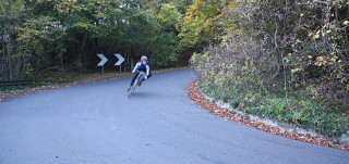
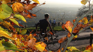
The descent from this ridge doesn't come until a few kilometres later but boy is it a good ‘un. It drops sharply through more woods -coloured today with the oranges and reds of a New England Fall- before suddenly you're screaming around yet another switchback bend gripping at the brakes with full force.
The final big climb on our route goes over the shoulder of Leith Hill, which on its summit is the highest point in Surrey (294m). By the time we reach the foot of the climb we're both grateful that we're taking one of the easier ways up. Depending on how you count them, there's at least eleven different ways on and off Leith Hill - some steeper, rougher, more sinuous than others. If you so wished, the hill could form the basis of a whole afternoon's riding in itself.
 From the foot of the descent -a nice 60km/h job with just enough curvature to keep you on your toes- our loop takes us back through a less arduous part of the county. Amongst these final sections is the back road down to Walliswood and the gradual climb up Weare Street - two prolonged sections of narrow lane that epitomise many of the smaller routes around this way.
Making tunnels through the plentiful woodland that litters the Surrey countryside, these roads are too narrow, twisting and hidden away to have been turned into rat runs by the impatient motorists who tear past on some of the more major routes. This corner of the country may sometimes seem overrun with big houses, big cars and people with busy schedules, but idling down these leafy back lanes gives you some appreciation of why the commuters flocked here in the first place.
Distance: 57.5km
Highest point: 248m (Leith Hill)
Total climbing: 783 metres
Local Amenities: There are lots of pubs dotted around the route. The Abinger Hatch in Abinger Common serves decent food at reasonable prices. Just off the loop, The Parrot at Forest Green also comes highly recommended. The servery at the top of Box Hill offers snacks and hot and cold drinks as well as a fantastic view over the Surrey countryside.
Which way?
(All distances are approximate. R = turn right; L = turn left; SO= cross straight over; SP = signposted)
This route starts from the village of CAPEL, serviced by the A24 and Ockley rail station just half a mile to the west. The village centre is marked by a church, a pub and petrol station. From here:
- Take Vicarage Lane out of the village.
- R at end of road onto Trig Street.
- L at T-junction in NEWDIGATE then follow the road around bends out of village.
- L at junction in PARKGATE (SP: "Leigh").
- R at end of road (10.5km) and past LEIGH village sign.
- L at next turnoff in the village and follow road to its end in BETCHWORTH.
- L onto Old Reigate Road (15km; SP: "Dorking").
- R onto Station Road at the next junction.
- SO roundabout to start climb (15.5km) on B2032 to PEBBLE COOMBE.
- L at the top of steep section (18km; SP "Box Hill, Headley").
- L again at next junction (SP "Box Hill" - ignore the No Through Road icon on the sign, it's not true).
- Follow road through National Trust grounds at the summit of BOX HILL to start descent. Beware of speed bumps and sharp hairpin bends.
- L at foot of descent (25km; SP "Dorking").
- L to join cycle path immediately before roundabout.
- Descend ramp to pass through subway under dual carriageway then L upon immediately exiting tunnel.
- R where cycle path meets lane.
- L at junction SP: "Surrey Cycleway" and "Ranmore Common" to start climb.
- R at end of road in RANMORE COMMON.
- L at crossroads (SP: "Abinger"). Take care at sharp bends half way down the descent.
- SO crossroads (with A25) at foot of descent.
- L at next turning (35.5km; SP: "Abinger Common") to begin climb then continue through village.
- R at end of road in ABINGER COMMON and continue over summit to start decent.
- L at end of road (43km SP: "Ockley B2126").
- R at next junction towards Walliswood.
- L at end of road in WALLISWOOD (48.5km)
- L at junction SP: "Okewoodhill"
- L at end of road in OAKWOODHILL (the spelling varies depending on what sign/map you're looking at).
- R at next junction (SP: "Surrey Cycleway") then keep left where road meets Ruckmans Lane.
- SO crossroads (with A29) onto Weare Street (51.5km).
- R at end of Weare Street (56.5km) onto Coles Lane.
- This road leads you back to Capel passing OCKLEY RAILWAY STATION on the way.
- SO dual carriageway (A24) to continue along Coles Lane.
- L at end of the road in village.
- Finish at CAPEL village centre (57.5km).